Ecological effects of sea level rise in the northern Gulf of Mexico
The northern Gulf of Mexico has a wealth of natural resources and an economy dependent on healthy coasts. However, the combined impacts of rising sea level and tropical storms on coastal areas will be dramatic and present a significant threat to coastal communities and ecosystems.
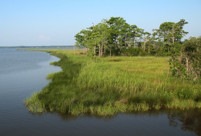
Salt marsh at Weeks Bay, Alabama (Photo: S. Stephens, UCF)
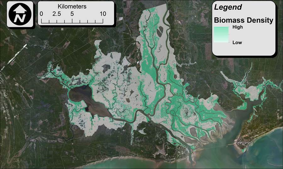
The effects of sea level rise (SLR) will be felt along coastal beaches and in estuarine waters, with consequences to barrier islands, submerged aquatic vegetation beds, sand and mud flats, oyster reefs, and tidal and freshwater wetlands. Managers of these coastal resources must be aware of the potential consequences of sea level rise and adjust their plans accordingly to protect and preserve the resources under their care. The Gulf Coast provides critical habitats for a majority of the commercially important species in the Gulf of Mexico, which depend on inshore waters for either permanent residence or nursery areas. The ecosystem services provided by these coastal habitats are at risk from rising sea level.
A team led by the University of Central Florida is assessing the risk to coasts and coastal habitats from SLR in particular and climate change in general (e.g., changes in precipitation). The 5-year project involves collaboration among the Universities of Central Florida and South Carolina, Florida State University, the Apalachicola, Grand Bay and Weeks Bay National Research Reserves (NERRs), and Dewberry, Inc.
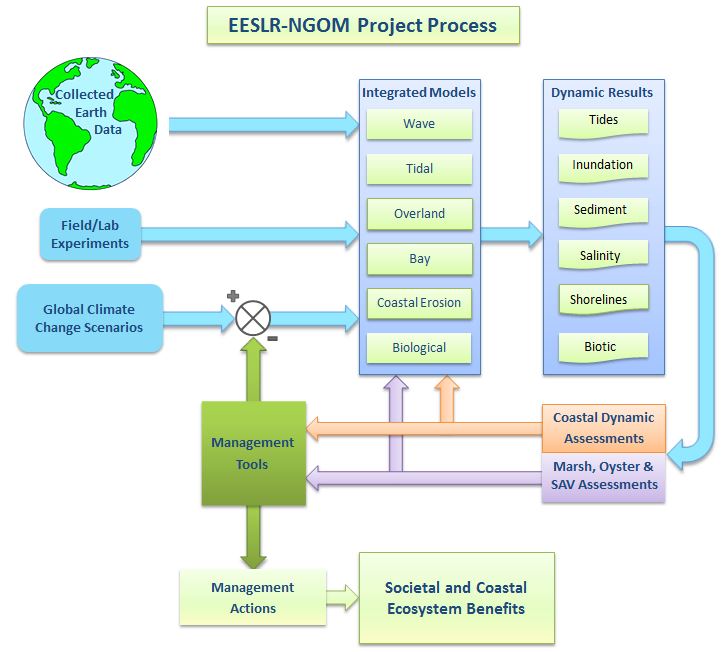
Project flowchart: click to enlarge (Diagram: CHAMPS Lab, UCF)
The research team-including members from UCF’s Departments of Civil, Environmental, and Construction Engineering and Biology and the Nicholson School of Communication-is combining the results of field studies and computer modeling to predict how different marsh and coastal species will react to new hydrological conditions, including rising sea levels and storm surge. This multidisciplinary project builds on laboratory experiments and field observations and experiments at the three NERRs to inform a suite of predictive computer models.
The team is combining models of water circulation, overland flow, and coastal hydrodynamics with models of sediment transport from the watershed to the sea. These models will incorporate shoreline erosion and predict sediment loading to coastal marshes and waters, as well as estuarine and bay salinity transport. The physics/biological-based models and assessments will allow for forecasts of intertidal marsh evolution and inform marsh, seagrass, and oyster habitat models. The ultimate predictions will include sediment loadings to the estuary as a result of overland flow and salinity transport in numerous bay systems, all of which will be used to model the impact of climate change (with focus on SLR) on intertidal marshes, oysters and submerged aquatic vegetation at the three NERRs. The science team members are working with coastal resource managers to ensure that the results of this project are as useful as possible for their planning needs.
Coastal hydrodynamics
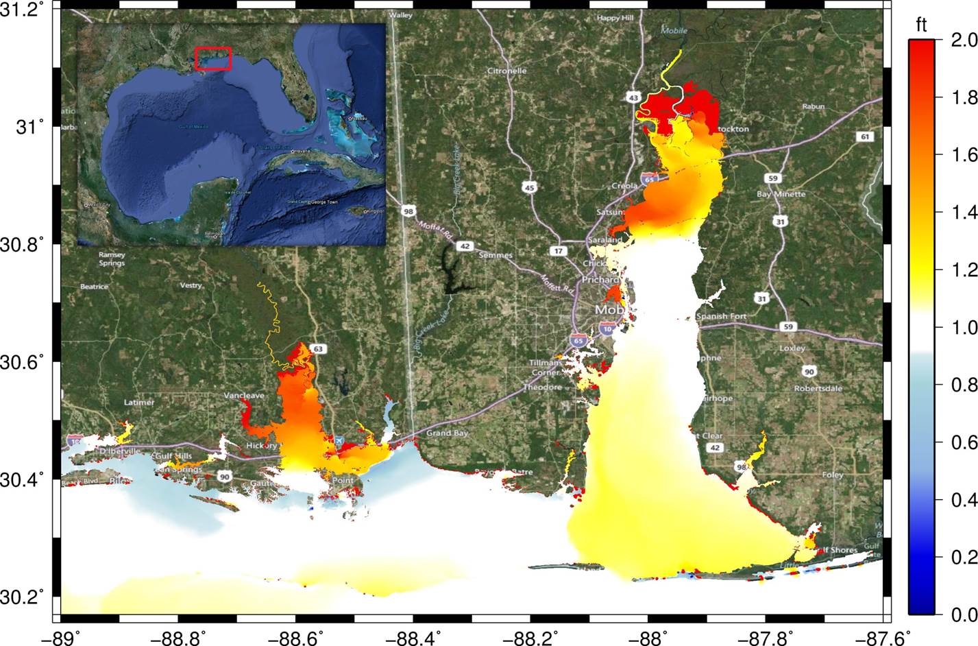
Relative change in storm surge if Hurricane Katrina had occurred with sea level rise (Diagram: CHAMPS Lab, UCF)
The project team is applying existing models of circulation and transport from the watershed (SWAT & WASH123D) to the sea (ADCIRC-2DDI & POM), including waves (SWAN). The numerical models make use of existing bathymetric and topographic data (e.g. LiDAR) and related data sets, numerous ongoing synergistic activities, as well as field and laboratory experiments and analyses. Tides, wind waves, and hurricane storm surge are being simulated for the region of the Northern Gulf of Mexico that includes the entire Mississippi, Alabama and Florida panhandle coasts and floodplains. Hydrodynamic impacts are being assessed with respect to NOAA SLR scenario guidelines of low, intermediate low, intermediate high and high SLR for 2050 & 2100. This effort will span the Northern Gulf of Mexico region and include hydrodynamic assessments of surge (e.g., case studies and changes to floodplains) and tides (e.g., nearshore and embayment tidal constituents and residuals, mean low water, mean high water).
As one element of this project’s work, storm surge results in flooding and has powerful effects on the coastal zone. This figure shows the increase in storm surge that would be caused by Hurricane Katrina if it occurred under a sea level rise scenario. The model incorporates waves, tides, storm surge, land use changes, habitat changes, and shoreline evolution. The results of this project will let researchers combine various SLR predictions with the ecology models and predict how both incremental SLR and extreme events might impact coastal regions in the future. This will help managers protect our natural and human-built coastal resources.
Marsh plants, oysters, and sea level rise
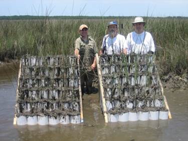
A marsh organ (Photo: CHAMPS Lab, UCF)
In the second part of this project, particular field and laboratory experiments (e.g., marsh organs and oyster ladders) are being conducted at the NERRs to parameterize saltmarsh and oyster habitat models. Different marsh plant species prefer different depths of water, as seen in the top photo: light green vegetation in shallow water is Spartina alternaflora (saltmarsh cordgrass) and darker green vegetation in slightly deeper water is Juncus roemarianus (black needlerush). While the differences in depth are not very large, they are very important for the plants themselves. Marsh plants thrive when the ground that they grows on is located at a “sweet spot” between mean high water (MHW) and mean low water (MLW). As sea level rises, so do MHW and MLW. In order for saltmarsh grasses to remain productive the rate of accretion (the buildup of organics and inorganic sediments) must keep up with the rate of sea level rise.
The marsh organ photos show a device that contains rows of mud-filled PVC pipes to simulate various levels of marsh elevation. By planting grasses that are particular to the local marsh, researchers can correlate the grasses’ response to various sea levels. As a result of the field experiments, a marsh equilibrium model can be developed. The information about marsh grass response is combined with field data collection, including total suspended solids, sediment cores, overland soil classifications, sampling of marsh grasses throughout the region, and sediment elevation tables. The marsh model is then coupled to a tidal hydrodynamic model that results in a capability to project marsh response for multiple scenarios of SLR.
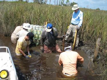
Researchers harvesting a marsh organ to measure plant growth (Photo: CHAMPS Lab, UCF)
In order to study how oysters will react to sea level rise and related sedimentation, researchers have created oyster ladders to test the effects of sea level and sedimentation on oyster survival. Empty oyster shells are attached to the ladders at different depths, and researchers monitor the growth of baby oysters that attach to the shells. These field experiments are being accompanied by lab tests to study how the size of sediment grains in the water also affects oysters.
Working with natural resource managers
One critical component of this project is to ensure that results are useful for coastal managers. This process is facilitated by an applications committee that has been involved in tool development from the project start. Annual stakeholder workshops with coastal resource managers are being held to provide an overview of the project and products, learn about noted/expected ecological changes and concerns, solicit input on products’ content/format, identify gaps in products, user groups, and target audiences, and connect the project with other ongoing SLR research and extension efforts. The general workshop structure includes a project overview, scientific presentations with time for questions and answers, facilitated panel discussions on ecological changes, concerns about SLR issues, reactions to the presentations, and identification of product user groups, a scientific planning meeting, and a focus group.
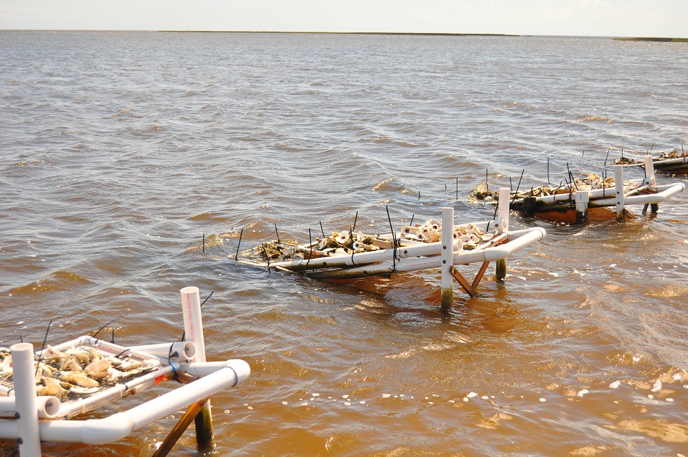
Oyster ladders deployed at low tide (Photo: CHAMPS Lab, UCF)
The project will result in products that provide support for managers in assessing marshes, oyster reefs, and submerged aquatic vegetation, predicting wetland stability, and identifying restoration locations for marsh and oyster habitats. In addition, decision support tools are being produced that will enable managers to predict future coastal erosion rates for management-specified shorelines. Project outcomes will enable the management community to prioritize risk management strategies, reformulate setback requirements, improve guidelines for construction of breakwaters and other coastal infrastructure, and assess water resources impacts and protection needs.
This research is funded by U.S. National Oceanic and Atmospheric Administration (NOAA) Grant NA10NOS4780146.